Fractal Geography
Fractal RiversAs we saw in the first chapter, rivers are a great example of a natural branching pattern. They are formed by repeated erosion following thousands or millions of years of rain falling and draining away downhill. Small streams (called 'tributaries') merge together to form bigger rivers, which join with other rivers, and eventually they empty into a lake or the ocean. The fractal geography of rivers explains a basic mystery of rivers: How is it possible for a river to always be flowing, even when it hasn't rained recently?
The answer is that the network of tributaries collects water from a huge surface area of land and funnels it into the river. Even though it may not have rained recently where you happen
to be watching the river, somewhere upstream it probably rained on some of the tributaries, possibly hundreds or sometimes even thousands of kilometers away.
 Figure 1. Tributaries joining the Rio Grande at Elephant Butte reservoir. Image courtesy of Google Earth. A watershed, also known as a drainage basin, is an area of land where any rain that falls will drain into the same river or body of water. Watersheds are very important to understand, as they illustrate the functional interconnectedness of land.
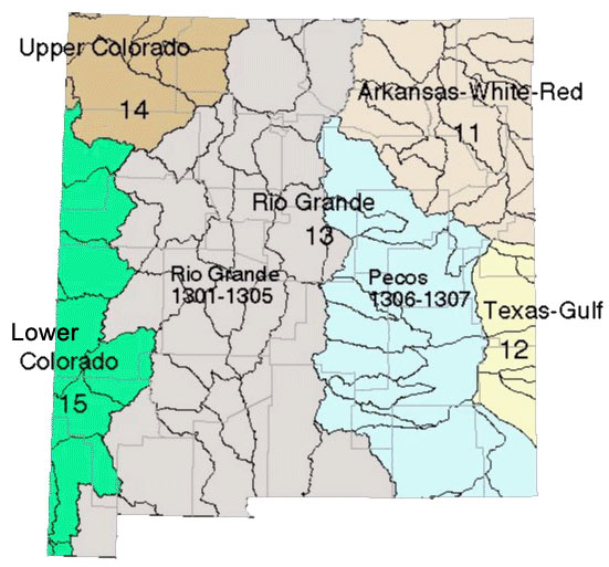 Figure 4. Watershed map of New Mexico. Note the wiggly black lines do NOT represent rivers, rather they are boundaries of smaller drainage basins within the
larger watersheds. Image courtesy of NM Water Resources Research Institute.
Watersheds can be tricky to interpret on a map, and - like any good fractal - they exist at multiple scales. The map above shows the main watersheds of the state of New Mexico. Rain that falls in the central part of the state drains into the Rio Grande river. The Rio Grande basin (labeled '13') is divided into two parts: the left drains directly into the Rio Grande, while the basin on the right drains into the Pecos River. They are grouped together because the Pecos River joins the Rio Grande further south in Texas, before the Rio Grande empties into the Gulf of Mexico and the Atlantic Ocean. On the west side of the state, there are two separate basins, '14' and '15', which drain into the Upper and Lower Colorado River. These two rivers join further west, at Yuma Arizona, before emptying into the Sea of Cortez and the Pacific Ocean.
The line dividing the Rio Grande basin from the Colorado River basins is extremely important. It is part of the Continental Divide. Rain that falls to the west of this line will drain into
the Pacific Ocean, while rain that falls on the east of this line (even if it's only a few meters away) will end up following a radically different path and draining into the Atlantic Ocean.
This is a great illustration of the chaos theory principle of Sensitivity to Initial Conditions, in which small differences in the starting conditions
lead to big differences in the outcome.
Let's look at the watersheds of New Mexico a little more closely. The map in Figure 4, above, of New Mexico's watersheds shows 6 main watersheds, each in a different color. Each of
these watersheds is further subdivided into several smaller basins. It's important to realize that the squiggly black lines are NOT rivers, but they are the boundaries of the
sub-basins within each watershed.
We can zoom in a little and look closer at the section for the Rio Grande Basin. Compare the figure below with the one above, to see how they relate to each other.
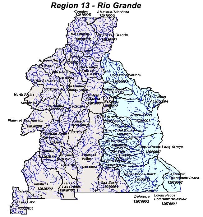 Figure 5. Map of the watersheds of the Rio Grande Basin. Image courtesy of NM Water Resources Research Institute. At this scale, we can see some of the small tributaries that collect rain from within each of the sub-basins. This map takes a little while to figure out. The Rio Grande itself is difficult to pick out, since all the rivers are colored alike, regardless of their size. You can find the Rio Grande at the south edge of the map where it crosses into Texas, just below Las Cruces. Of course, watersheds are fractal in nature, so we could keep zooming in and looking at smaller and smaller watersheds, that is sub-basins of the sub-basins. Even at the very
local level of arroyos (small, often dry creeks) on the side of a hill, you can define small scale versions of watersheds, distinguishing the branches of the network of arroyos that are directly connected from
those that are more distantly connected.
Question: How many gallons of water are diverted through the San Juan - Chama project each year? [ ] How many gallons is that each day? [ ] |
||||
|
<- PREVIOUS NEXT -> © Fractal Foundation. |


